Toronto Subway System: Maps & Guide
Your complete guide to using the Toronto Subway for getting around and exploring the city
The Toronto Subway system, consisting of 3 underground subway lines, forms the heart of the City of Toronto's public transit system. The TTC subway has a total of 71 stations (more any other system in Canada) located along 70 kilometres of track. During weekdays, the system carries over 1 million passengers daily. Trains are referred to as the TTC Rocket or simply the Rocket. Most of the popular attractions in Toronto are just a short walk from a subway station. For those further away you can transfer to a TTC Streetcar or Bus to complete your trip.
Toronto Subway Routes
Looking at a Toronto Subway map, Line 1, Yonge-University-Spadina, forms a long 'U' shape with Union Station at the base of the 'U'. Union Station is in the heart of the downtown city centre and serves as a major transporation hub for connecting to the Go Train, TTC Buses and Streetcars. The western leg routes north through many stations including Queens Park, Yorkdale, and Sheppard all the way to the city of Vaughan. The eastern leg of the 'U' routes north through York Mills eventually terminating at Finch Station. This line is designated as line 1.
Line 2, the Bloor-Danforth Line, runs predominately west to east between Kippling Station in the West and Kennedy Station in the East. This line crosses both legs of the Yonge-University-Spadina line and has connections to it at Spadina, St. George and Bloor-Yonge stations.
Line 3, the Scarborough RT, was permanently closed in August 2023. It is being replaced by express bus service between Kennedy Station and Scarborough Centre.
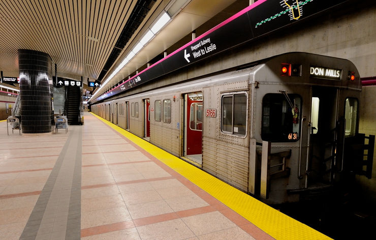
Line 4, the Sheppard Line, runs east from Sheppard - Yonge Station on the Yonge-University-Spadina line to Don Mills Station.
Toronto Subway times and frequencies
Subway Trains run every 2-3 minutes during rush hour and every 4-5 minutes the rest of the day on both the Yonge-University-Spadina and the Bloor-Danforth Line. Service on the Sheppard Line operates every 4 - 6 minutes throughout the day. The system operates between approximately 6 am and 1:30 am Monday through Saturday and 9 am until 1:30 am on Sundays. Transfers valid for trips in one direction are available free from transfer terminals at subway stations. These allow you to continue your trip on a TTC bus or streetcar.
Accessibility
Currently, 52 Toronto Subway stations, including all 5 stations on the Sheppard Line are wheelchair and scooter accessible. The TTC plans to make all stations accessible by 2025. Elevators provide access at accessible stations. Most subway cars have one or two special wheelchair positions, however, any train may be boarded by someone in a wheelchair or scooter. Cars with wheelchair positions can be identified by the blue and white International Symbol of Access displayed on the outside. Accessible TTC subway stations are indicated by wheelchair symbols on the Toronto Subway system diagram below.
Toronto Subway Fares
To find information on how and where to purchase a Toronto Subway Fare please refer to our page on transit fares.
If you need more information, maps and schedules for the TTC Subway and Rapid Transit System, visit the official TTC website.
Toronto Subway Map with Streets
This map combines the best of both worlds — a schematic Toronto Subway Map with clickable stations that open a street map showing the surrounding area.

Interactive Subway Map with Streets and Attractions
Open an Interactive Toronto Subway Map with Streets. Find the next departure near you with our Click&Go Map and Route Finder.
More Info for Getting Around Toronto on Public Transportation
- Fares
- Subway
- Streetcars
- Buses
- Go Transit
- Bike Share Toronto
- Airport Service
- Real Time Transit Alerts
- Transit Tips
Photos
-

Entrance to Museum Station, TTC Subway System cc licensed photo by Richie Diesterheft -

Inside Museum Subway Station, Toronto -

The interior of a Toronto Subway Car cc licensed photo by sillygwailo -

Subway Map inside a Toronto subway car cc licensed photo by mayeesherr. -

Photo Credit: Danielle Scott - cc license via Flickr


