The PATH Toronto
The PATH located under Downtown Toronto is the world's largest below ground shopping complex making it a great place to explore during inclement weather
The PATH in Toronto is a 28 kilometre network of underground walkways lined with shopping, services and entertainment. It also provides a way for pedestrians to move around downtown Toronto and link to public transit without dealing with traffic and weather.
The PATH is the largest below ground shopping complex anywhere in the world. It boasts nearly 1200 shops and services covering 371,000 square metres. The history of the PATH dates all the way back to the year 1900 when Eatons constructed an underground tunnel between their main store and the Eatons Annex. In 1927 a tunnel was built to connect Union Station with the Royal York Hotel. Both of these tunnels remain a part of the current PATH system. In the 1960s and 70s underground malls were developed and eventually linked together. In many ways the PATH is much like a gigantic underground mall, however it is much more than just that, as it connects so many parts of downtown Toronto together including multiple subway stations and office towers.
You will find PATH network maps within many of the buildings that are connected by it. The PATH has links to many popular Toronto buildings, hotels and attractions including Eaton Centre, Hockey Hall of Fame, Roy Thomson Hall, Rogers Centre, Air Canada Centre and Toronto City Hall. The path is also directly connected to 6 subway stations on the Yonge-University-Spadina Line.
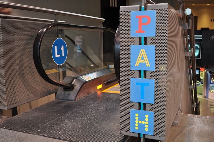
Each letter in PATH is a different colour and represents a different direction of travel. P is red and indicates south; A is orange and indicates west; T is blue and indicates north; H is yellow and indicates east. Before you go, download a printable Map of the PATH. For complete details about The PATH see the official website.
Facts For Your Visit
Fee: No
Hours: Varies by business
Address: Toronto, ON
Phone: 416-726-8000
Official Website: The PATH Toronto
Directions
| TTC Subway Line | Nearest Station | Walking Time |
|---|---|---|
| Yonge-University-Spadina | See Below | 0 Minutes |
How to get to The PATH Toronto by TTC Subway
No bus needed. The PATH is directly accessible from Dundas, Queen, King, Union, St. Andrew and Osgoode Subway Stations on the Yonge-University-Spadina Line.
Map & Instant Route Finder
Click&Go Map and Route Finder with public transit, walking, driving or cycling directions. Get up-to-the-minute transit times for your route.
Accommodations near The PATH Toronto:
Photo Gallery
-

Shops inside Toronto's underground PATH
